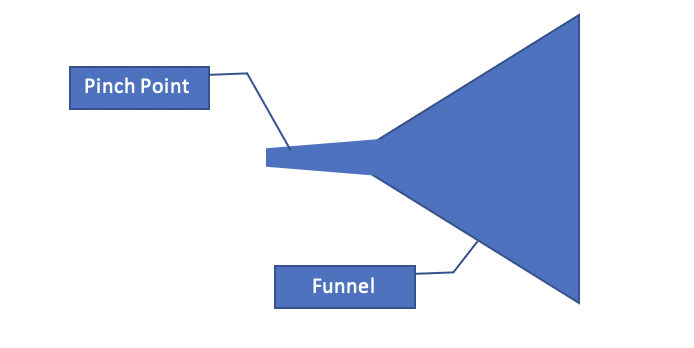
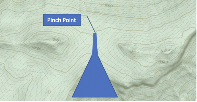
One of the most important features that I look at when determining areas to hunt are funnels and pinch points. Sometimes these terms are used interchangeably, but there are differences between the two. A funnel is a location where animals begin to congregate to move from point A to point B. A funnel can be a rather large area like the bottom of a hill with a drainage in which the animals come from all different locations. A pinch point on the other hand is a precise location where most of the animals will travel through once they entered the funnel. A pinch point is more or less the end of the funnel. The graphic below gives a good understanding of the differences.
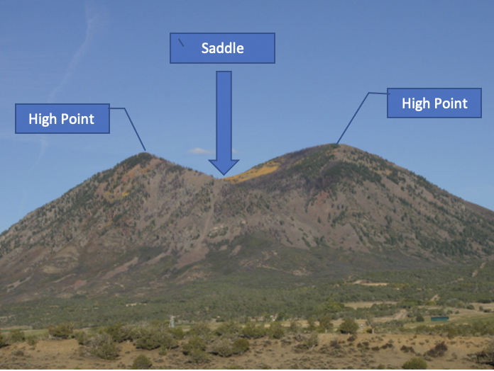
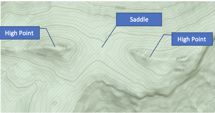
Now that we understand what funnels and pinch points are and the differences between the two, how are these identified in the wilderness? The first step in the process that I use is looking at a topographic map to identify key terrain features that offer the animals the “path of least resistance.” Just like us humans when we walk in the woods, animals try their best to avoid tough terrain that will make them expend more energy than taking an easier route. For example, let’s take a look at a saddle. A saddle can be defined as a low area on a ridge between two high points. The below illustration shows how a saddle looks when viewing one from the side as well as how it looks on a topographic map. The third illustration shows the first funnel/pinch point illustration overlayed on the map to give a better understanding on how these features look on a map. Now, why is a saddle important? An animal is more likely to travel up the hill and reach the peak at the saddle point versus the high points because it is simply just easier to travel over a mountain or hill at the lowest elevation (less climbing). Now, this is just one example of a pinch point, but now that you have an idea of what to look for, what other features can be used in this same way?
Finding these pinch points in the areas that you hunt can be extremely valuable and ultimately will help you see more animals as these locations will be the main travel points from where they go from A to B. These pinch points can include other terrain features like cliffs, rockslides, valleys, etc. or even other features like paths avoiding highly used hiking trails, water sources in areas where water is hard to find, hedgerows for cover, and more. Take some time to really learn your area to find these likely pinch points.
Now, not all pinch points are created equally. Once I have identified the main pinch points in my hunting area, I then take it to the next step and ask myself; why would they be using this pinch point over another? Remember that an animal travels for 3 main reasons. Aside from moving during the rut, they move to get food, water, and shelter. By looking at the surrounding areas at each of the pinch points, I look to identify the closest places where the animal is likely bedding, where it is likely going for water, and where it will go to eat. I can then eliminate certain pinch points if any or a combination of these three are missing.
The last (and in my opinion the most important part) step I take is actually going out in the field and checking these pinch points out to look for sign. If I am seeing all different kinds and good amounts of animal sign, I know I have found a heavily used pinch point that may be beneficial to hunt near. If I am not seeing much, it may not be an area that the animals generally move through so I can rule that area out.
So the next time you head out into the woods, take a step back, look at some topographic and aerial maps, locate some pinch points where animals are likely to funnel to, verify it in the field, and I guarantee you will start seeing more animals and getting more shots!
If you have any questions for Brian you can get in contact with him through the Cervicide Hunt Club or message him through IG: